Sometimes (too many times?) I head off on an adventure with only the slightest of information. Yesterday was one of those times.
I needed to get from the Las Vegas area to Highway 395 along the eastern Sierras. I had taken the route through Death Valley many times and wanted to try something different. I consulted someone who was very familiar with all the routes and based on her recommendations I decided to take US-95 to Nevada 266, then California 168. That way I could go to Ancient Bristlecone Pine Forest before connecting to US-395 at Bishop. That was enough of a plan to get me going.
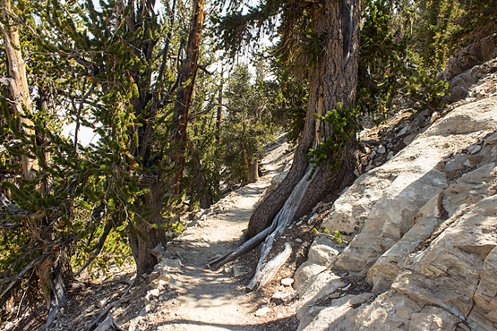
Everything went fine and I arrived at the Schulman Grove visitor center, where the pavement ended. The center was closed, but info boards outside showed two hiking trails. The four mile long Methuselah Trail seemed appealing. I knew “Methuselah” was supposed to be the oldest bristlecone pine ever found and I supposed the trail went there. So I headed off, packing water but not accounting for the fact I hadn’t done any serious hiking all summer, that all I’d eaten that morning were a couple of bananas and a fitness bar, and that the elevation was over 9,000 feet.
A half-mile marker came up rather quickly. It seemed twice as far to the one-mile marker. But I was feeling good. It seemed I’d walked three times as far by the time I decided the two-mile marker must’ve been missing, but, oh there it was. I was still feeling good, though. Half way. Piece of cake. But the last two miles felt like four miles, all uphill. Each bend revealed another uphill stretch. I kept thinking the next summit would be the last. Nope.There were benches along the way. I started resting at each one. Also at spots between benches. My pulse was up and my legs were becoming unsteady. Hike fifty yards, lean against a tree, breathe deeply. Hike another fifty yards, sit on a boulder, breathe deeply. Another hiker came by and asked if I was okay. Yup, just old and not acclimated to the elevation. And probably hungry.
I finally reached the four-mile marker. There had been no three-mile sign. I could see the roof of the visitor center at the top of the rise. I would make it.
Back at the road was a sign indicating Patriarch Grove, fifteen miles on a dirt road. Next to it was a warning sign. Heck, I’ve driven bad roads before. Off I went.
Washboard and walnut-to-potato sized rocks can make fifteen miles feel like forever. But at least I wasn’t walking. Suddenly there was a quarter mile of pavement. Okay.The elevation climbed to 11,000 feet. The mountain tops were treeless, just a carpet of sagebrush. The final mile of “road” was especially rough, just shy of Jeep trail status. Everything in the Rolling Steel Tent was shaking and bouncing. Woo-hoo! Adventure!
By the time I reached Patriarch Grove, even the sage was gone. Just bristlecone pines growing from gravel and rock. It was like a moonscape. With a scattering of trees.
Despite its roughness, the drive had given me the time to recuperate. I walked to the top of a hill with no problems, despite the thinner air. But as I climbed back into the van my right calf cramped up very badly. AAAaaaack! I lost control of my ankle and foot. I massaged the muscle, tried to flex my leg. Aaaack! No luck. The cramp continued for about fifteen minutes before it eased up enough to drive. I was probably more dehydrated than I thought.
I found a camping spot part way back down the mountain. I stretched out to do some serious resting and fell asleep until 4:20 AM. I guess I needed that.
Now I’m in Bishop, back within cell coverage, catching up on email. The main reason for making this trek might, almost literally, go up in smoke. Most of the National Forests in the area have been closed down because of fire danger. The TV crew’s permits are now invalid and they’re hustling to see if they can get a location on private land. Bob found a camping spot in a part of a forest that is still open. I’m headed there after posting this. We’ll see what happens.


