Monday, June 30, 2014

Seeing is misbelieving

When I was wandering about yesterday, looking for a campsite with lots of sunshine, I saw this on Google Satellite View:

The gray patches looked like areas where people had camped before. I went to investigate.

No, the gray patches were actually piles of stumps, limbs and other debris from logging. Oh well. At least there was an easy way to turn around.

I. Like. Big. Maps, and I cannot lie

The Forest Service publishes Motor Vehicle Use maps showing where you can drive and, as a bonus, where dispersed camping is allowed.

I'm a map nerd. I love studying them and then comparing them with the real world. So I'm excited to have the actual paper map. WOOT!

And this is just one side!

You can get them online, but sometimes you don't have a connection when you need it. Or your battery is dead. Paper never lets you down. As long as you keep it dry. And in an emergency, you can burn it for heat. Try that with your smart phone or laptop.

Zoom in, zoom out, scroll scroll scroll, zoom in, zoom out, scroll scroll scroll...

Oops

It being Monday, the ranger station in Sisters was open. I drove in to get some information. They gave me a fine, big, map of the local National Forest roads with dispersed camping areas marked. It was interesting to learn that what Google Maps showed as a continuous swath of National Forest actually has a bunch of patches that aren't. And I happened to have spent the previous night a few hundred yards into private land.

Ah.

So I found a new, even better place. Larger clearing, more sun, closer to town.

Now, if only there were a place in Sisters to get fresh bagels and a variety of schmears.

Sunday, June 29, 2014

Bye, Mt. Hood, for now

After five days it felt like it was time to move on.

The majority opinion would probably say I should head to the coast, see those famous Oregon beaches. That would be nice. Oregon law has made the entire coast accessible to the public. However, there is no free camping. You have to pay (a lot) and make reservations months in advance to stay at one of the state or federal campgrounds. It's high season and the Independence Day weekend is coming. So, no. Not now, anyway.

I was here. Now I'm not.

Instead, I've headed down the dry side of the Cascades, which is also warmer. And less popular. The land is flatter and the forests are less dense. Right now I'm camped in the Deschutes National Forest west of Sisters, which is north of Bend.

Instead of Mt. Hood, I have the Three Sisters mountains. Mt. Bachelor is a little farther south. I guess the Bachelor couldn't maintain a relationship with any of the Sisters. But he has skiers to distract him from his solitary life.

Too late

Saturday, June 28, 2014

Today's buzz

I was sitting, enjoying the rare Pacific Northwest sunshine. I had gazed at the distant view, examined the closer view, and I had gotten down to noticing details. Like the bees.

These bees are smaller than honey bees. They fly close to the ground. Not too odd, seeing as how the flowers in my little ridge top clearing are also close to the ground. But these bees don't seem interested in the flowers.

They keep landing on bare patches of dirt, on pebbles, on rocks. They pause one or two seconds, then buzz off to another bit of dirt or rock. I guess collecting pollen isn't their thing. At least not today. But what are they up to? It's not like I can get down there and see, because, zip, they're gone. I can't even get a photo.

Hmmmm, maybe they're pouncing on bugs too small for me to notice. Carnivorous bees. The dreaded "meat bees" some friends say infest the Sierras? Uuuumm, no. Meat bees are actually yellow jackets, and I know them when I see them. These are smaller and less pointy. They're something else. Miners? Hole nesters? This quote is not encouraging:

"...the Willamette Valley is home to 250 bee species, and the deserts east of the Cascade Range hold 600 to 800 species."

Any apiary nerds out there with an answer? The Mt. Hood Rock-hopper Bee?

Thursday, June 26, 2014

Mr. Blue Sky

Looking down at a chunk of the Mt. Hood National Forest. The Columbia River is on the other side of the tan hills. Obscured by clouds are Mt. Adams, the remains of Mt. St. Helens, and Mt. Ranier.

Oh, look, I'm back at the ridge top campsite! My whiney self whined too soon. I was a third of the way back to Pendleton when the clouds started breaking. Rather than drive further, I pulled off at an exit, parked by a store and took a nap. (I'm excellent at napping.) When I awoke the depressing gray overcast had become cheerful partly cloudiness. And my batteries were charged. Hurray! So I went back. That'll teach me to trust the National Weather Service too much.

Another strategic retreat

Sigh. I like my campsite in the Mt. Hood National Forest, but the overcast is making it hard to keep my solar batteries charged. So, it's either head away from the wet western part of Oregon or turn off the fridge and throw away perishable food. Or binge eat all of it.

The National Weather Service says it won't be sunny here until Monday. Accuweather is slightly more optimistic, saying Sunday. Either way, I gotta flee. Sigh.

Swell

Wednesday, June 25, 2014

I moved up

The previous campsite had that nice deep-in-the-forest quality to it, but there was very little opportunity for sunlight and too much opportunity for mosquitoes. So I studied my maps and Google satellite views, looking for larger clearings. That meant moving out of the valleys and up onto the ridges.

Now, instead of being at the base of the trees, I look down on them. And instead of my view being about fifteen feet in any direction, I can see all the way to Mt. Adams, in Washington. (My view of Mt. Hood is blocked by other ridges.) Best of all, being up here gives me three bars of 4G mobile signal. Sweet. And (so far) no mosquitoes.

Now, if only the cloud cover would break up and give me some blue sky like yesterday. Oh, I forgot, this is the Pacific Northwest.

Break out the Deep Woods Off!

I have a nephew with the Forest Service. In the Mt. Hood area. Lucky me, that's where I wanted to camp. So he gave me some tips on boondocking sites.

The trick is finding a spot with a break in the forest where sunlight can reach my solar panel. I found one.

Too bad the cell signal is weak. Oh well, can't have everything.

Tuesday, June 24, 2014

And I just missed the solstice

If someone were to say, "Wanna see a memorial to the soldiers and sailors of Klickitat County, Washington, who lost their lives in WWI?" you'd probably pass.

But if someone were to say, "Wanna see a replica of Stonehenge a guy built overlooking the Columbia River?" you'd probably answer, "Hell yeah!"

Quaker pacifist, Samuel Hill, probably wasn't thinking about attracting tourists when he built his memorial, but it turned out to be marketing genius.

Monday, June 23, 2014

My own Oregon trail

Sunday afternoon it settled in my mind. Oregon it is.

I bid my thanks and farewells to Ophelia and Peter, stopped at Jiffy Lube to have them change the oil and rotate the tires, then headed off on I-84.

Interstates are dissed as not the way to see Real America. But I'd seen a lot of the country via blue highways. I'd dealt with narrow roads and slowing to 35 or even 25 miles an hour for all the little Real American towns along the way. It's nice, for a change, to cruise along on wide highways with extra lanes and gentle curves. It's nice having fewer things to be watchful for. Thanks, Dad, for midwifing the Interstate system. (He was Chief of Construction and Maintenance for the Bureau of Public Roads. Ike lobbied for the highways, Dad got them built.)

I-84 roughly follows the Oregon Trail. Indians, trappers, Lewis & Clark and wagon trains had already figured out the easiest path to the Columbia River and the coast. Just grade and pave it so I can come along and be grateful for it.

I'm in Pendleton right now. It's too early for both the Pendleton Roundup and for needing any wool apparel. But I'm going to call it a day here.

Sunday, June 22, 2014

Idaho is a very tall state

So, there I was, stopped at a gas station near Glacier National Park, feeling like I’d had more than my fill of rivers, lakes and forested mountains, with more of it in every direction.

I’d spent the previous night by a beautiful creek near Darby, Montana. And I was bored. I wanted to move on. But I didn’t know where I wanted to go, where I wanted to be. I only knew I didn’t particularly want to be where I was. Whatever itch I had, the scenery wasn’t scratching it.

Maybe the problem was that I was alone. Maybe I’m not as reclusive as I’d assumed. During the past ten months on the road I’d been perfectly content in some less-than-wonderful patches of the country. Because, hmmmmm, I had other van dwellers to socialize with. A wee bit. (Don’t make me turn in my introvert card.)

So I texted some house dwelling friends in Boise to see if they’d like a weekend guest. They would. At least I’d have a place with a shower while I contemplated my next move.

There aren’t many paved roads through the middle of Idaho. The straightest line would have been highway 12 over Lolo Pass. But that would mean miles and miles of twisty roads. That’s fun in a sports car but not in a top-heavy van. So I took I-90 west to Coeur d’Alene, then US 95 south to McCall and state road 55 to Boise. It was a 580-mile schlep (plus the 190 miles from the Darby camp to the afore-mentioned gas station). Fortunately, most of the weekend traffic was going the other way.

Being here hasn’t lead to any revelations about where I want to head next. The coast is one option, even though it means a boring slog through eastern Oregon, even though coastal weather is damper and cooler than I like. I could make my way down the coast to San Francisco (a former home town), then cut across to the Sierras. Or I could head straight to the Sierras. I know some van dwellers summering there. I could head back to central and northern Idaho, even though it would be backtracking. I could go south, but to higher elevations in order to avoid the heat. I should check the extended forecast for northern New Mexico. I have my NM state park annual pass to use up. I could draw an option out of a hat.

I don’t know. I really don’t.

Up until a few days ago, just setting off to a new place—any new place—got me charged up. Now? There’s a whiff of existential despair in the air.

Thursday, June 19, 2014

Hi, Montana

I'm next to Lost Horse Creek, between Hamilton and Darby, Montana. I'm more likely to find fish than a horse.

We all live in a buried submarine

What are the remains of the USS Hawkbill doing in Arco, Idaho? I guess a cannon isn't impressive enough.

Tuesday, June 17, 2014

Split-level river

Anyone can build a dam across a river. But it takes a visionary to build one down the middle of a river.

Such is the hydroelectric dam on the Snake River in Idaho Falls. That's the eponymous falls to the left.

The trouble with rain

When it rains I need to be inside. There are options when I’m near civilization. Cafés, libraries, malls, museums and such. If I’m out in the boonies, there’s only the van. Not needing to spend all day in a van is what makes van living tolerable.

When it rains I don’t get solar energy. That means I can’t use my electronics very long while I’m cooped up in the van. It also means I have to turn the fridge temperature to the upper limits of safe food preservation.

There are three places to be in my van. The driver seat, the toilet and the bed. The driver seat gets old rather quickly when I’m not actually driving. The toilet gets old rather quickly even when being used for its intended purpose. That leaves the bed. No matter how I try to keep busy and engaged while on the bed, sooner or later I end up napping. Then I can’t sleep at night. Sleepless rainy nights get very long. 

I do a lot of thinking when I can’t sleep. Then I start thinking in circles. Then I try to think about other things but end up back in the circle of annoying thoughts, checking the time, seeing it’s only 9:43 PM, taking Benedryl to knock me out, waking up very groggy at 11:03 PM, thinking in circles that now include weird snippets of drug-fogged dreams…

That’s why I drove 204 miles yesterday to get out of the rain. That’s why I’ll be here two more days, until the front leaves western Montana and northern Idaho.


Monday, June 16, 2014

Half a dam

This is the remains of the Sunbeam Dam on the Salmon River. Others have told its story better than I can, so I'll quote from the Osprey blog:

The Salmon River is the longest undammed river in the continental United States. But it wasn’t always that way.
In 1910 Sunbeam dam was erected on the Salmon above its confluence with the Yankee Fork. The dam was built to supply cheap power to gold mining operations along the Yankee Fork. The dam supplied power to stamp mills and dredges for just over a year before the mining operation went bankrupt and closed.
A historical marker adjacent to the river claims that the Idaho Department of Fish & Game contracted demolition of the dam in 1934.  However, locals know a different story. Idaho Governor Cecil Andrus wrote in his memoir, “A party or parties unknown ran a dynamite-laden raft into Sunbeam Dam. The dam blocked the annual salmon run. The party or parties unknown were never caught, a fairly unusual circumstance in this thinly populated country.”

Surge

As I approached Challis, Idaho I figured I should top off my tank before making a southward run for the sun. There was a station at the junction of highways 75 and 93, but it was boarded up. Not a good sign.

I turned north into Challis proper and pulled into the next station I saw. The pump said to pay inside. "We're sorry, we had a big power surge a few moments ago and the pump billing is down." Okay.

I drove a couple of blocks to the next station. A man at the pumps said, "We're sorry, we had a big power surge a few moments ago and the pump billing is down." (Sheesh.) "But it should be back up in a moment." A Subaru with kayaks on top didn't believe the "in a moment" thing and took off for the next station. Hey, they had rivers to run and all that.

Within a few seconds, the guy said, "Okay, we're back up. What can I get for ya?" Oh, they pump gas for you? Hadn't encountered that in a long time, since I was in a state where self-serve was outlawed.

We chatted as he pumped gas. "We're glad to have this rain. It's been very dry."

I smiled. "It messes with my recreation plans, though. Different people have conflicting interests."

The kayakers came back from the other station. Guess those pumps were still down, too.

"Oh, what sort of plans?"

"I camp full time. I just came from Redfish Lake."

"I heard it's nice up there. I got married a couple of years ago—she's from Utah—and I've been meaning to take here there."

"It's gorgeous—when the clouds don't hide the mountains."

About 40 miles south I realized I should have gotten his name and taken his photo for this blog. But it would've held up the kayakers.

Sunday, June 15, 2014

Wait for it... wait for it...

I woke up to overcast. Not a tragedy, just not happy-making. I packed up and headed north, toward Stanley, Idaho, a hub for Salmon River outdoor stuff.

The lady at the SNRA office had spoken highly of the lakes south of Stanley. I had lunch at a picnic area at Alturas Lake. The wind was cold and the lake choppy. I'm sure it's a much nicer place in better weather.

I skipped Pettit Lake (mostly because I saw the turn too late) but decided to try Redfish Lake. I was apprehensive. It had all the marking of campgrounds filled with big RVs and noisy people. But the mountain ahead was very dramatic.

See why they call them the Sawtooth Mountains?


Okay, I'd check things out. At least for future reference.

I drove to the last campground on the south shore. It looked brand new and spanking clean. And it was mostly empty. There was a parking area and a trail down to the "beach." I grabbed the camera and went for a walk, even though it wasn't beach weather.

Sort of fjord-like


It wasn't good photography weather, either, but the the geography was impressive. I decided to stay a night.

I returned to the Rolling Steel Tent and bundled up against the increasing chill. Then it started to rain. Oh great. I can take cool weather, but combine it with rain and I want to hightail it to better weather. I got online and checked the weather for the region. Three days of clouds and rain. Yikes, subfreezing nights! Must flee! What about further south? It looked like I had to get almost to Salt Lake City to get out of this front. Sigh. I'd make a strategic retreat in the morning then resume my northern Idaho expedition later in the week. A lot of driving, but better than freezing—in summer.

The rain stopped after about an hour and, surprise, a bit of sunlight peeked out. Oh look, it's clearing! I could get some better shots of the lake and mountains. But I had to wait about a half hour for the clouds to clear in an artistic way.

However, lack of cloud cover means it's going to get colder tonight. I can always come back.

Meanwhile, at Alturas Lake

The water from this tap (the only one) was COLD, as in one degree from slush.

Don't get too bold, kid

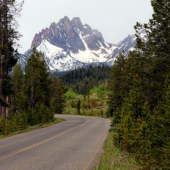
I went exploring again yesterday. The lady at the SNRA office had suggested Baker Creek Road. "There are a number of campsites along it, but the last one before the road closure gate is particularly nice."

Yes, the last one was a nice site, and it was occupied. But just opposite was East Fork of Baker Creek Road. Ooo, what's up there? I mean, it has a name and a sign, so it must go somewhere significant.

The road climbed and got narrower. And rougher. Walnut sized rocks in the road became lemon sized ones and then potato sized ones. I crawled and bounced along. There was the mountain on one side of the road and the cliff on the other. No places to turn around. Certainly no places to camp. Maybe further up.

I came to an open gate with signs telling snowmobilers to stay on the road. Snowmobilers must come up here for some reason. I pressed on, imagining the road would lead to an open area somewhere near the top of the mountain or would descend into the next canyon.

The road was getting very marginal. Another "road" forked off steeper up the side of the mountain. It was more like a mountain goat trail. No thanks.

The road started to descend. Ah, I thought, it's headed into a valley. No. It just made a hairpin turn and started up again.

Ah, man. Doing this in a Jeep, with someone following for backup, would be one thing. But alone in a big old van was probably foolish.

I eventually came to a spot wide enough to execute an eight- or nine-point turn. I got out to assess my progress and discovered my blind side was about an inch from scraping against a tree. Good thing I'd checked.

The return trip was only slightly less worrisome. I kept thinking about what would happen if I encountered someone coming the other way. It was a one-lane trail with absolutely no room to squeeze over and pass. And I suck at backing, even on wide paved streets. Backing up a mile or so on a winding narrow road would be impossible for me.

When I finally made it back to the turnoff, I pledged to myself I wouldn't do something like that again. At least not without a local who knew the road. But I'd had an adventure I could share. A stupid one, but still an adventure.

[If I'd had cell reception and could have checked Google Maps I would have learned that, indeed, the road eventually opened up into wide hilltop clearings suitable for camping or tearing around on snowmobiles. Should've pressed on.]

Friday, June 13, 2014

Off the beaten track

Armed with my Forest Service tips and maps, and the feeling of confidence that comes with having a little information, I set off exploring this morning. Oh look! A dirt road! Where does that lead? And off I'd go.

There were times when the "road" got rocky, rutted, steep and narrow and I wondered whether there would be someplace to turn around or whether I was driving myself into a dead end squeeze. There were times when those wide-ish spots would appear that I debated turning around or continuing forward. I chose the latter. And I was glad.

From the top of Galena Summit


Well, others have been this way, so...


Oh look, a nice creek!


I didn't get photos of the really bad parts of the road because I was too busy driving


Just when I thought I was in a terribly remote spot that only crazy people would go, I came across a street sign


And then a beautiful meadow


Along the way I saw several great camping spots, except they lacked sufficient sun, any cell signal, or both. Say, what about the areas behind the SNRA office they told me about? I checked it out and found a sunny spot by an abandoned corral, with 4G service. And no one else around. Pretty good luck for Friday the 13th.

Thursday, June 12, 2014

I might be here a while

I went to the Forest Service's Sawtooth Nation Recreation Area information center this morning to get the full scoop on dispersed camping in the area. The simple answer was essentially, "Anywhere that isn't private property."

"So I can just pull off on any road in National Forest land?"

"As long as you're not blocking the way."

(Looking at a detailed map) "Wow, cool."

"We try to make it easy for people to get out and enjoy this beautiful area."

That means I have a lot of exploring to do.

Meanwhile, this is where I'm camped today. It's not far from Ketchum, a few steps from Trail Creek. And I have a few bars of 4G cell service.

Hemingway was here

I'm in Ketchum, Idaho, visiting a friend and hanging out. The local Forest Service office pointed me toward some nearby camping areas and I spent the afternoon scouting them out. The unpaved roads are in nice shape, and even though it hasn't been long since they were covered with snow, they're hard packed, dry and rather smooth. I picked out a nice spot on Warm Springs Road, steps from the river, with plenty of solar exposure and, surprisingly, a bit of cell reception. However, I spent the night on the other side of Ketchum, on Corral Creek Road, because it was easier to get to after dinner with my friend.

Tuesday, June 10, 2014

Leave your mark

At many high schools they haul in a big boulder, place it on the front lawn, and let each graduating class paint it up. Woot! Class of '14!!!

Well, they've topped that Arco, Idaho. They've been painting the side of a mountain since at least the 1920s.


I imagine the height to which you're willing to schlep your ladders and buckets of paint says something about the superiority of your class.

How do you feel about your boulder now?

Monday, June 9, 2014

Gazillions of holes

When I bought the Rolling Steel Tent the back windows were covered with perforated vinyl. That was good, because it helped keep thieving eyes off the contents of my van. Yet I could also see out.

But the vinyl was a little ratty, and in the past few months it had gotten worse. It was time to replace it. It took longer to deal with the guy in the sales office than to have it installed. Hey-presto, job done in ten minutes.

Friday, June 6, 2014

RST Renovation: The Edit

I've edited my possessions several times in the past nine months. There were things I thought I'd need that I didn't. Unlike some full time van dwellers, I didn't approach this adventure with the attitude I was creating a micro-apartment. I'd be camping. Even so, I overestimated my needs.

Here are the things I edited out today. Too many clothes and shoes, man. And I haven't needed eight forks, knives and spoons. Two of each is enough. Four towels? No, two. And look how many containers I don't need now that I've better sorted what I'm keeping. Until the next edit.

Thursday, June 5, 2014

RST Renovation: Project 3

The original 12-volt electrical system I created worked okay, but it was a bit of a mess. And some outlets were hard to get to. So I got a proper fuse box and rewired everything. Vent fan, lights, fridge, etc.

That looks slightly more professional.

Because everyone keeps asking

I used to find myself in situations—dates, parties, lunches with coworkers—when the question was, "What's your favorite movie?" Since I didn't keep a mental ranking of every film I ever saw, I usually answered, "Oh, I don't know. There are so many, each with things I really like." That would throw a wet blanket on the conversation. Social interaction was never one of my strong points.

Finally, I decided I'd just pick a movie from my cluster of favorites to use as my standard answer. But it had to be one that others were unlikely to name, because I needed to be different, quirky. I had a personal image to maintain. So I picked Brazil. Problem solved. I had a ready reply. Conversation could continue, because I had to explain/defend why I liked a weird Orwellian dystopian tragic romance so much. (Because, duh, it's a weird Orwellian dystopian tragic romance.)

These days people ask me, "Of all the places you've been in your van dwelling wanderings, which did you like best?" Urgh, here we go again.

As with movies, I've decided to just pick one. It still needed to fit with my imagined self-image, though. It needed to be different and unexpected.

"I'd have to say Slab City."

And then I explain/defend why, continuing the conversation, enhancing my oddball image.

I know, people ask that question hoping I've found some secret Shangri-La they can go to. Sorry, not yet. I've had some sublime moments now and then. Some bits of excitement and fun. But no mind-blowingly awesome paradise of endless bliss overload. But I'll let you know if I ever find it.

Wednesday, June 4, 2014

RST Renovation: Project 2

It's great having a 12-volt refrigerator, even though it's the single largest drain on battery power. Following the lead of others, I added insulation to it. I taped some pieces of 1-inch foil-backed foamboard into a crude box and lid. That helped keep things cooler and reduced power usage a wee bit. It got me through the mild desert winter.

If a little insulation is good, then more is better, especially as winter turned rapidly into summer in Slab City. So I wrapped a couple of layers of Reflectix around the foamboard box. Good. But I knew I could make something better if I had access to a table saw and mitre saw. My brother-in-law in Oakley, Utah, has those.

After too many runs to Ace Hardware in Kamas and Home Depot in Park City, behold that better thing.

Two-inch foil-backed foamboard contained in a wood box (for durability), with a little Reflectix on the outside to reflect sunlight and make it look all techie. (Why, yes, that is a flux capacitor in my van.) I can add more Reflectix if I need to.

The odd notch in the back of the box is to allow air circulation to the compressor.

It's not quite done. I'm going to mount a fuse block on the side to centralize all my wiring. Notice the two 12-volt sockets? (Front and side.) One is to plug in the fridge and the other is for whatever else might need power.

The fridge used to live between the driver seat and the cabinet that was where the passenger seat used to be. Now the fridge will be going where the cabinet used to be, and the cabinet is going to the county dump. The things that were in the cabinet will be redistributed, and some things will be discarded/donated to allow the redistribution.

Next up: cleaning up the wiring.

Monday, June 2, 2014

Living with less

Can you fit your life into 60 square feet? That's the area of the standard cargo van. Can you fit your life into 60 square feet and not have the rest of your possessions stuffed in a storage facility or a friend's attic? The totality of your stuff in the back of a van, with room left for yourself to move around and to sleep? And if you could, would you be happier?

This video covers some of the same well-trod ground of the Less Is More message we've been hearing for the last half century or more. But it absolutely applies to this van dwelling life I've chosen to live. In fact, we van dwellers are way ahead of what's said here.


Besides the huge edit I had to do to go from living in a house to living in a van, I've edited several times more along the way. I'm about to do another edit. The goal is to get rid of one 58 quart container's worth of things. Because I've learned greater empty space in the van is worth more than many of the things occupying it. It will make me happier than owning stuff.

Sunday, June 1, 2014

The most violent thing I've ever experienced on purpose

I haven't been an adventure seeker. Except scuba diving, a couple of bungee jumps and a moderate river rafting trip. That's about it. The last time I was on a roller coaster was the early '80s, before they got extreme.

When I learned they were offering bobsled rides down the track used in the 2002 Olympics, I had to do it. Because whenever I'd watch the winter games, I'd wish I could go down a bobsled run. Without a sled. Since there's very little chance of that ever happening, I jumped at this.


These specially made sleds have wheels. And roll bars. And seatbelts. And straps to hold onto. (Not as sleek looking as their ice counterparts.) They provide the driver.

You go about 60 miles an hour and it takes about a minute. You shake, bounce, get whipped from side to side. Your helmet knocks against the roll bar. You experience up to 4 Gs. You forget everything they told you about how to brace yourself. And you want it to last longer. WOOOOOOOOO!

We're Number 3! We're Number 3!

The most violent thing I ever experienced? I was rear-ended while on my motorcycle. I didn't want that to last longer.