Saturday, February 29, 2020

Seeing more of Mojave National Perserve than I’d planned

The fact there was no sign should’ve been a sign things wouldn’t go quite right.

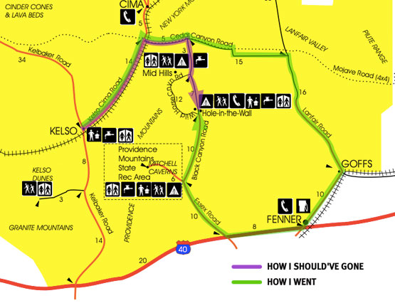
My goal was to get from Kelso to Hole-in-the Wall/Banshee Canyon/Ring Trail. There are two routes. One is to go south on Kelbaker Road to I-40, east to Essex Road, then north to the Hole-in-the-Wall information center. The trailhead is there. And the road is paved all the way. But that’s the long route from Kelso.

The short way—or what was supposed to be the short way—is to go northeast on Kelo-Cima Road, east on Cedar Canyon Road, then south on Black Canyon Road to the information center. However, coming from Kelso there’s no sign pointing to Hole-in-the-Wall, just a very small one with the road name. To complicate things, the official map calls the road Mojave Trail. I blew past it until I saw a large sign facing the other way. Okay, I pulled a U-ee and made the turn.

Cedar Canyon’s pavement ends after a couple of miles and turns into horrible washboard. It’s the kind that even at low speed had me imagining every nut and bolt on the Rolling Steel Tent loosening, all the windows cracking and at least one wheel coming off while everything in the van rearranged its location. But I chugged along.

I chugged along past Black Canyon Road. If it was marked, I missed it.

Washboard distorts my sense of distance. A hundred yards feels like a mile. I should’ve reset my odometer at the junction and referred to the distances marked on the map. Too late now. And I wasn’t certain I had missed the turn yet.

Then I came to a T intersection. And a sign. Sun faded arrows pointed to places I knew nothing about. Okay, it was time to dig out my old GPS. Did it work anymore? And would it know these evil washboarded dirt roads even existed? If it can’t find Hole-in-the-Wall, can it at least give me a hint whether I should turn left or right? I plugged it in and it coughed to life. Then shut down. Oh no. Then rebooted. Oh good. It took a long time to find satellites. And then… Okay, there I am, almost to Nevada, and… turn right.

This dirt road smoothed out and eventually turned to pavement as it approached I-40. I took the Interstate west to Essex Road and cruised up the gloriously paved road to my destination.

One of my mottoes is Go places, see things, learn stuff. Well, now I know what a good chunk of the eastern half of Mojave National Preserve is like. Quite nice, actually, when you’re not being shaken senseless.

As for the Ring Trail through Banshee Canyon? Very cool. Worth the crazy drive. I just wish the canyon was longer. It’s the type of place to linger in, not march through. Or if you’re going to march through so you can get to the rings, come back and linger.


The rings were put there to help folks can climb up the last section of trail. The spikes that hold the rings would’ve worked fine by themselves, but the rings give the place a hook, a marketing point. “Did you do the place with the rings? Dude, you totally need to go. Oh, and no matter which direction you’re coming from, you’ll wanna come up from I-40.”

Just a little harder than climbing an ordinary ladder

Thursday, February 27, 2020

There’s an opportunity here, folks

Dear Park Service,

Please pipe in water from a hot spring to fill the old livestock tank at Barker Dam. Hot water in one section, hotter water in the other. People would pay.

Rock hopping, without the hopping part

Slip through here, climb up there, no problem

 The act of moving on feet and hands over rugged terrain has been given too many finely sliced names. Rock climbing, bouldering, scrambling, canyoneering… Whatever.

I didn’t use ropes or other special gear (unless you want to count my hat). I just got out there and made my way around on some of Joshua Tree’s piles of stone. Climb over this, crawl under that, squeeze between those, look around, enjoy it all. I was just farting around. I declare Rock Farting an official sport and will campaign to have it included in the Olympics.

Wednesday, February 26, 2020

Hooked on slots: Annie's Canyon

Thanks again to Josh, of California Through My Lens, for pointing me toward another fun hike. The hike starts with an easy stroll along the south side of San Elijo Lagoon, in Solana Beach.

It’s a little over a half mile from the street to the beginning of Annie’s Canyon. From there you have the choice of taking the switchbacks up the back side of the canyon or the trail through the slots. Well duh. The slots are the whole point of the place. Either way is rather short.


The idea is to go up through the slots and back down via the switchbacks. Or, as in my case, go three-quarters of the way up the slots until you reach a step up that’s about crotch high. All the surfaces were rounded and there was nowhere to grab to pull myself up. If two or more people are hiking together, they can do the you-push-me-up-and-I’ll-pull-you-up maneuver. But I retraced my steps, took the switchbacks to the top and came down from there—even though that’s in violation of the One Way sign. I met no one coming the other way, so all was cool.

It’s a little creepy entering from the top,
climbing down into who knows what

Josh explains that Annie’s Canyon “was off limits for a long time and had become a graffiti-ridden location until some residents took up the cause to make it pleasant again.” I believe Annie was the one who spearheaded that effort. Sadly, the graffiti is still there, scratched into the sandstone until Nature wears it away. Because some people are jerks.

The narrowest sections are only wide enough at the bottom for one foot in front of another, but the walls flare out so there’s hip and shoulder room. I didn’t need to do any sideways scooting. And at no time did I feel claustrophobic.

Tuesday, February 25, 2020

I love the beach on weekdays

The midweek winter “crowd” is thin. It’s pretty much surfers before work, moms and tykes during the day after it warms up, a handful of folks eating lunch, teens after school, then some families and surfers after work. And retired old farts like me hanging out all day and spending the night.

Monday, February 24, 2020

Wet feet

Enjoying the Pacific Foot Wash

The hat works for both desert and beach

It was beach time this afternoon. Not nearly-naked-and-frollicking-in-the-surf beach time. It’s still winter, after all. But the weather was nice enough for t-shirt, shorts and bare feet.

And Mondays are excellent beach days—if you like having the place to yourself. Almost. I’m generous, I don’t mind sharing my private strand. Some mermaids would be welcomed.

Hmmmm, got a sudden hankering for bouillabaisse

Splurge

This is the view from my campsite at Crystal Cove State Park, just north of Laguna Beach. It’s pricey, but it’s good to be back at the ocean.

Sunday, February 23, 2020

A wet corner of the desert

Like so many other things, I discovered California Through My Lens thanks to a YouTube recommendation. Josh’s videos and blog pointed me to some beautiful, fun, interesting and weird places. The other day I checked to see what he had to offer in the Joshua Tree/Palm Springs area. A hike to a waterfall I’d never heard of? Sure!

Tahquitz Canyon had been trashed by partiers and hobos until the Agua Caliente Band of the Cahuilla Indians cleaned the place up and started charging admission. The hike to the falls is a two mile loop with only a few spots that challenged my cardio system, joints, or sense of balance. The water makes the canyon lush with vegetation, a nice break from the desert.

Not the falls, a spillway from a water collection system

This is Tahquitz Falls

The air was pleasantly cool but the water was downright cold. That didn’t stop some hikers from jumping in. You might be able to see one of them to the right of the big boulder.

I’m glad I went early, before the sun was over the rim of the canyon. It feels more hidden, more intimate. I want to come back in the fall when the cottonwoods are golden.

Friday, February 21, 2020

A walk in the (national) park

The large angled rock used to be part of the large upright rock

I usually enter Joshua Tree from the south. I’ve driven past the Cottonwood visitor center and campground several times, never giving them a thought. (And not needing to stop, since I have a lifetime senior pass.) I didn’t know there was also a trailhead there. Until today. Cottonwood Spring, Mastodon Peak Loop and Lost Palms Oasis all start there.

I was up with the sun, had some oatmeal, got my act together and arrived at the trailhead a little after 8:30. There were only three other cars in the lot. Not only had I beaten the weekend crowd by coming on Friday morning, I had also beaten most of the beat-the-weekend-crowd crowd.

The temperature was pleasantly cool with a light breeze. Good walking weather. I was passed by a trio of bros and a family with four young kids. I was in no hurry. I diverged from the trail a few times to see what might be there. I took photos. I sat on rocks and luxuriated in the fresh air and silence. I was feeling good.

I got to the fork for Mastodon Peak Loop. Anything with peak in the name means an uphill climb. How much of a stress would this one put on my post-cancer cardio system? Go or don’t go? What the hell, don’t give up without trying.

Thank you, Park Service, or whomever

And I was fine.

If I’d had some bouldering skills and a climbing partner I could’ve scrambled to the top of Mastodon Peak. I went as far as I could.

Never having been someone who voluntarily pushed himself physically, this hiking stuff is a new experience. For my body and mind. Who is this guy who suddenly thinks, yeah, I wanna go up that mountain? Have the radiation and chemo done a number on me? Or is it the realization I might not have as much life left as I had presumed? I’ll think about it as I walk down the next trail.

Walk on

Most hikes I’ve taken have a section that’s just drudgery. But I’ve needed to keep slogging along in order to get to the cool parts, or to get back home.

This wash, for example. It’s loose sand and grit that sucks energy and a little progress out of each step. At least it’s not mud or snow. Or snow atop mud. Or ice.

Now that I think of it, the sand is just fine, thank you.

Ya go places, ya see things, ya learn stuff

I had never seen a type of cholla like the one a saw on this morning’s hike in Joshua Tree National Park. Short branches all neatly, geometrically, arranged around the main stalk. Other cholla I’ve seen are much more random in shape.

I googled when I got back within signal range and eventually learned these are called Blue Diamond cholla, or Clokey Cholla, Opuntia multigeniculata, Opuntia whipplei var. multigeniculata, Cylindropuntia whipplei var. multigeniculata. So now I know. I just need a chance to casually slip Opuntia whipplei var. multigeniculata into a conversation.

Thursday, February 20, 2020

Good ol' sunset photo

From outside Joshua Tree National Park, looking toward Indio and Palm Springs

Another former service station

This building on the fringes of Borrego Springs has been a number of things over the years. Now it’s a target for tagging and vandalism. And the photo subject for at least one passerby.


Wednesday, February 19, 2020

Down in the ground

There’s a slot canyon in Anza-Borrego Desert State Park imaginatively named the Slot. While the famous slot canyons of the Colorado Plateau are usually smooth tan sandstone, the walls of the Slot are gray sediment that tends to erode in lumps and chunks. It doesn’t create juicy yellow-to-pink-to-purple light, but it’s still enjoyable, in a different, slightly spooky way. More like descending through one of the less-awful levels of hell than slipping through a secret passageway to heaven. The oh-ee-yah, ee-oh-uh chant of the Witch of the West’s guards would be an appropriate soundtrack for this hike. Instead there were just the chatter and laughter of kids, and the wheezing and grumbling of old farts wanting to know how much farther it is and if it gets worse.