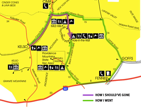
My goal was to get from Kelso to Hole-in-the Wall/Banshee Canyon/Ring Trail. There are two routes. One is to go south on Kelbaker Road to I-40, east to Essex Road, then north to the Hole-in-the-Wall information center. The trailhead is there. And the road is paved all the way. But that’s the long route from Kelso.
The short way—or what was supposed to be the short way—is to go northeast on Kelo-Cima Road, east on Cedar Canyon Road, then south on Black Canyon Road to the information center. However, coming from Kelso there’s no sign pointing to Hole-in-the-Wall, just a very small one with the road name. To complicate things, the official map calls the road Mojave Trail. I blew past it until I saw a large sign facing the other way. Okay, I pulled a U-ee and made the turn.
Cedar Canyon’s pavement ends after a couple of miles and turns into horrible washboard. It’s the kind that even at low speed had me imagining every nut and bolt on the Rolling Steel Tent loosening, all the windows cracking and at least one wheel coming off while everything in the van rearranged its location. But I chugged along.
I chugged along past Black Canyon Road. If it was marked, I missed it.
Washboard distorts my sense of distance. A hundred yards feels like a mile. I should’ve reset my odometer at the junction and referred to the distances marked on the map. Too late now. And I wasn’t certain I had missed the turn yet.
Then I came to a T intersection. And a sign. Sun faded arrows pointed to places I knew nothing about. Okay, it was time to dig out my old GPS. Did it work anymore? And would it know these evil washboarded dirt roads even existed? If it can’t find Hole-in-the-Wall, can it at least give me a hint whether I should turn left or right? I plugged it in and it coughed to life. Then shut down. Oh no. Then rebooted. Oh good. It took a long time to find satellites. And then… Okay, there I am, almost to Nevada, and… turn right.
This dirt road smoothed out and eventually turned to pavement as it approached I-40. I took the Interstate west to Essex Road and cruised up the gloriously paved road to my destination.
One of my mottoes is Go places, see things, learn stuff. Well, now I know what a good chunk of the eastern half of Mojave National Preserve is like. Quite nice, actually, when you’re not being shaken senseless.
As for the Ring Trail through Banshee Canyon? Very cool. Worth the crazy drive. I just wish the canyon was longer. It’s the type of place to linger in, not march through. Or if you’re going to march through so you can get to the rings, come back and linger.
The rings were put there to help folks can climb up the last section of trail. The spikes that hold the rings would’ve worked fine by themselves, but the rings give the place a hook, a marketing point. “Did you do the place with the rings? Dude, you totally need to go. Oh, and no matter which direction you’re coming from, you’ll wanna come up from I-40.”
Just a little harder than climbing an ordinary ladder


Interesting post. Mojave National Preserve is one of those places I wish I'd explored 20 years ago.
ReplyDeleteA good reminder to top off your gas and water when exploring "the wilds."
ReplyDeleteHere's an article on Joshua Tree enacting Darwin's law...
https://patch.com/california/banning-beaumont/dutch-man-german-woman-idd-as-j-tree-fatalities